Winter 2021/2022
Log in to replyHome › Forums › General › Non RS Chat › Winter 2021/2022
- This topic has 113 replies, 14 voices, and was last updated 2 years, 1 month ago by
 Andrew.
-
AuthorPosts
-
October 24, 2021 at 11:06 AM #181145
Early indications are winter is a little bit later than the previous 2 years, throughout the world. Some reports from the Skiing world have had some cold weather and even some snow. INTRODUCTION Winter continues to move closer in the Northern Hemisphere. There were some big snowfalls across western North America over the past week and in the Alps snow levels reached the valley floor at ski regions in Austria and Switzerland. Other mountain ranges on both continents posted fresh snowfall up high.
AUSTRIA FORECAST The current largely dry conditions should end by Thursday when a cold weather front will bring light to moderate snowfall, potentially 10-20cm (4-8 inches) of fresh by the weekend. Temperatures also dipping to double digits below freezing at the weekend.
SWITZERLAND FORECAST Staying largely dry and sunny until late Thursday when a front will move in dropping temperatures below freezing to low levels and delivering 10-20cm (4-8 inches) of snowfall; a nice freshen up by the weekend
FRANCE FORECAST Temperatures on French glaciers staying around zero and after more sunny and dry weather midweek a major front is expected to move into the Alps from Thursday with a potential for 20-40cm (8-16″) of fresh snow. This will, hopefully, be a big boost of cover, especially coming just days before Les 2 Alpes is due to open.
ITALY FORECAST Temperatures are falling further and snowfall is expected on Italian peaks over the latter half of this week. Perhaps not so heavy snowfall as further north but still 10-20cm (4-8″) is expected on glaciers by the weekend and temperatures 5-15 degrees below freezing up at 3,000m. Cold in resort too, freezing overnight even in the valleys.
GERMANY FORECAST Mostly sunny for the next few days with cool temperatures in the Bavarian Alps. Early signs are for a temperature plummet and heavy snowfall next weekend with a front moving in and temperatures expected to dip as low as -10C on higher peaks.
Honorary Member
October 24, 2021 at 11:12 AM #181146SCANDINAVIA FORECAST Cold temperatures are forecast for the coming week in Northern Scandinavia with moderate to heavy snowfall through the remainder of the week and into the weekend, temperatures staying subzero overnight. Assuming things play out as expected things will look very wintery by this time next week.
SPAIN / ANDORRA FORECAST A more changeable week than the past 10 days or so with more cloud and rain in the forecast. With temperatures dropping that rain could potentially be snow on higher slopes by the weekend.
USA WEST REPORT Plenty more snow along the mountains of the western US with a wintry look from California up to Washington State. There have been several periods of snowfall, the latest on Sunday-Tuesday bringing up to a foot (30cm) of snowfall to the Tahoe region. Nowhere has announced an early opening as yet so it is now just over three weeks until resorts like Mammothare scheduled to kick off their 21-22 season. The other good news is that the wintry weather coupled with heroic efforts by huge teams of firefighters means forest fire danger that threatened some resorts is finally waning, Kirkwood announced at the weekend they’d been given the all-clear to open.
USA WEST FORECAST A series of storms is set to move through over the next week bringing weather highs and lows. More windy periods, more precipitation and hopefully more snow, although the temperature fluctuations between the 40s and high 50s/low 60s Fahrenheit may limit this. However, overnight lows will be close to freezing.
MIDWEST REPORT A year ago ski areas in the Midwest were among the first to open in North America. Temperatures have been dropping but it is still looking a little too warm for any to open at present. Especially with warmer weather and sunshine over the weekend.
MIDWEST FORECAST It is getting cooler for the week ahead with overnight temperatures dipping down to around freezing and daytime highs in the 40s/low 50s Fahrenheit, so snowmaking opportunities are getting closer if perhaps not yet quite here.
USA EAST REPORT The past few days have seen some quite stormy weather along the East Coast, with heavy rain, wind and even lightning strikes in some areas. But it remains fairly warm, too warm for the region’s famous snowmaking arsenal to fire up.
USA EAST FORECAST Drier for the next few days and temperatures overnight in mountain regions getting close to zero. But currently, it looks warmer again for most areas at the weekend and it still looks unlikely that any centres can start snowmaking just yet. When temperatures do consistently dip below freezing centres can fire out enough snow to open within 48 hours or so and it’s not unusual for resorts to open in the region before the end of October.
CANADA WEST REPORT It has been quite a snowy week across western Canada’s ski slopes with most of the resorts in the region posting images of their runs getting increasingly deeply buried. We’re now only just over a fortnight away until the first ski centres in the region are expected to open their first runs for 2021-22. The past few days have been a little drier to start this week, but it has stayed cold up in the mountains.
CANADA WEST FORECAST A largely dry week forecast with plenty of sunshine but overnight lows at or a few degrees below freezing. Therefore, snowmaking systems could be fired up at some centres if required.
CANADA EAST REPORT It has been another autumnal week in Ontario and Quebec with temperatures dipping closer to freezing, but still without any sign of snowfall. Instead, there’s been a good deal of rain over the past few days.
CANADA EAST FORECAST After a lull in the rainfall midweek, it’s looking like more rain for the last few days of the week and into the weekend. Temperatures remaining cool and close to freeing on the ski slopes.
so not a lot of snow yet 🥶
Honorary Member
October 24, 2021 at 11:41 AM #181147blimey, thats pretty Thorough Mr Bob Fish, the weatherman !! keep it up Bob !
No nothing.
No Mods. No rockers. Just a chunky knob, thats now been replaced by an RS knob innit.
No tackiness.
Std as Ford intended, but with a space saver wheel and jack and nuts and wheel brace. oh.. and flaps, a man has got to have flaps.
Innit?
October 24, 2021 at 12:27 PM #181149😹😹😹👍
Honorary Member
October 24, 2021 at 12:30 PM #181150Could I also get the winning Euro millions numbers for this week?
Collins Cp2 map. Ramair induction. Mountune mud flaps. Scorpion Sports Cat. Scorpion Tracker. Wind deflectors. NB washer jets and shark fin aerial. EBC Grooved discs, YellowStuff pads. Airtec Intercooler, Miltek cat back with titanium tips. Collins quickshift. DSC Controller
October 24, 2021 at 12:44 PM #181151Well done @bobcat 👍👌😀
October 24, 2021 at 12:58 PM #181152October 26, 2021 at 7:59 PM #181286Canada’s real first significant snow this winter
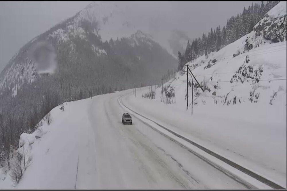
Up to 20 cm of snow expected for Coquihalla Highway.
Honorary Member
October 26, 2021 at 8:07 PM #181287October 26, 2021 at 8:48 PM #181292What a comprehensive report
October 26, 2021 at 8:52 PM #181293@gary1234, 👍 Things are starting to cool down now in the Northern hemisphere. Hong Kong reported some of the lowest temperatures for years.
Honorary Member
October 27, 2021 at 1:04 PM #181303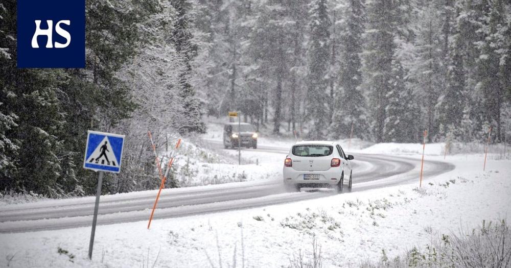 WINTER CAME TO SCANDINAVIA VERY EARLY: 48 CM SNOWFALL IN FINLAND AND -27°C FORECASTED FOR SWEDEN! Extremely cold forecasted conditions are slowly starting their manifestations in Scandinavia. On Tuesday, 19. October 2021, -18,0°C was already measured in Latnivaara, Swedenalthough GFS modes saw a potential only up to -12°C for northern Sweden for Tuesday morning. Enontekio in Finland reported -16,0°C, for the next days sees a possibility of temperatures up to -21/-22°C what should mean after calculations extremely cold -27/-28°C in the coldest valleys in Sweden, Norway, or Finland in the upcoming days. The coldest morning is still forecasted for Sunday, 24. October 2021, with extreme frosts in northern and central Scandinavia, with a possibility of temperature records in Kiruna, Gallivare, Lulea regions in Sweden or a possibility of temperature to be very close to the temperature records in Karasjok or Kaukoteino region, Norway or Enontekio, Kittila or Inari region, Finland. Moreover, extreme snowfall after a blizzard is already reported in northern Sweden and northern Finland – in Sweden regionally around 30 cm and in Kittilä Kenttärova, Finland, anomalous 48 cm! Snow cover deep like this is in October in the region very rare and it will very probably support a decline of minimum temperatures in the region during upcoming nights.
Cold air from Scandinavia even temporarily interrupts an Indian summer period in Europe, with a fall of maximum temperatures below +15°C and morning frosts around -5°C in valleys in Central Europe between 22.-26. October. Severe frosts should into Scandinavia at the end of October and in early November 2021 quickly return (between 27. October and 3. November 2021), with similar temperatures up to -27/-28°C after a blizzard. Watchers have noticed untraditional temperatures at level 10 hPa -they reached above Greenland -44°C above the Baltic region, southern Scandinavia, and northern Russia almost -70°C. These anomalous conditions should be associated with anomalous cold blasts in Scandinavia, together with a persisting October 2021 NAO- phase, with often Mediterranean lows and Arctic blasts in lower latitudes (and very cold Scandinavia).
Honorary Member
October 27, 2021 at 1:27 PM #181305⬆️⬆️⬆️⬆️White Dacia Sandero, good spotting that Bobcat😁🤔😉
Collins Cp2 map. Ramair induction. Mountune mud flaps. Scorpion Sports Cat. Scorpion Tracker. Wind deflectors. NB washer jets and shark fin aerial. EBC Grooved discs, YellowStuff pads. Airtec Intercooler, Miltek cat back with titanium tips. Collins quickshift. DSC Controller
October 27, 2021 at 2:16 PM #181307October 27, 2021 at 2:30 PM #181308shorts on down south here Bob, touched 19c and sunny on Richmond hill at lunchtime !
No nothing.
No Mods. No rockers. Just a chunky knob, thats now been replaced by an RS knob innit.
No tackiness.
Std as Ford intended, but with a space saver wheel and jack and nuts and wheel brace. oh.. and flaps, a man has got to have flaps.
Innit?
-
AuthorPosts