Winter 2021/2022
Log in to replyHome › Forums › General › Non RS Chat › Winter 2021/2022
- This topic has 113 replies, 14 voices, and was last updated 2 years, 1 month ago by
 Andrew.
-
AuthorPosts
-
November 1, 2021 at 5:20 PM #181472November 3, 2021 at 7:03 PM #181564
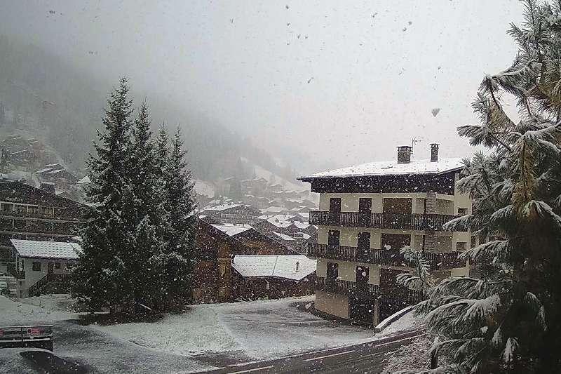
@Frenk at last things are beginning to cool down and start snowing. The second storm of the week is already underway in the southern and western Alps, with rain and snow set to spread further north and east later today, before it finally reaches the north-eastern Austrian Alps overnight. This morning, snow has already fallen to as low as 1000-1200m across some western parts of the Alps (e.g. Les Gets, pictured) with snow possible to 800m in places across the western Alps later today. The rain/snow limit will be higher further east, at least to start with, before also descending towards 1000m later in the day or overnight. Thursday will see skies begin to brighten across the south-western Alps, though most areas will still be cloudy with flurries to relatively low levels. Friday and Saturday should see a more general improvement in the weather, with excellent snow conditions expected in the small (but increasing) number of open ski areas across the Alps. Another 10-30cm of snow is expected to fall quite widely at altitude over the next 24 hours, with 40cm or more in a few favoured spots, especially in the southern Alps and close to the main Alpine Ridge (including the likes of Zermatt/Cervinia, Saas-Fee, Andermatt, St Moritz, Livigno, Passo Tonale and the Dolomites).Honorary Member
November 3, 2021 at 7:18 PM #181568@bobcat: Excellent news! Thanks a bunch. Can’t wait for a round trip on high altitude. And I still haven’t drifted a proper doughnut in snow yet 😆
Revo Stage 1 – JCR super low seating frame – Mishimoto gas pedal spacer – DSC sport controller
November 3, 2021 at 7:29 PM #181569@Frenk, just hope the snow doesn’t disappear as quick as it arrives 😸👍 The next major snow is around Wednesday/Thursday fingers crossed the prediction is right
Honorary Member
November 3, 2021 at 7:32 PM #181570Hoping our American/Canadian members can let us know when the snow arrives with them 👍
Honorary Member
-
This reply was modified 2 years, 5 months ago by
 bobcat.
November 3, 2021 at 8:35 PM #181581I bet our Scandinavian friends delve already in waist-deep white powder. Heja Sverige! 😄
Revo Stage 1 – JCR super low seating frame – Mishimoto gas pedal spacer – DSC sport controller
November 3, 2021 at 9:08 PM #181583@Frenk, whilst they have some early white powdery stuff it has not amounted to much yet, SCANDINAVIA FORECAST Generally snowy weather is set to continue into early November in Scandinavia over the coming week with most days looking likely to bring precipitation and temperatures close to freezing throughout, especially at higher elevations and northerly latitudes. More likely rain further south.
Honorary Member
November 9, 2021 at 7:28 PM #181847Update for the coming weekend
AUSTRIA FORECAST The cold snowy weather that moved into Austria ending the warm, summer-like temperatures and sunshine to end October is set to stay for at least a week with moderate to heavy snow showers forecast through to Friday. Drying out but staying cold at the weekend.
SWITZERLAND FORECAST As with the rest of the Alps the weather is looking to stay cold and snowy for the rest of this week. Temperatures well below freezing, reaching double-digits below up on the glaciers, where the weather may cause some temporary closures. Some areas may see 60cm (two feet) of snow up high by the weekend (hopefully). Skies should start to clear from the weekend.
FORECAST The cold snowy weather that moved into Austria ending the warm, summer-like temperatures and sunshine to end October is set to stay for at least a week with moderate to heavy snow showers forecast through to Friday. Drying out but staying cold at the weekend.
SWITZERLAND FORECAST As with the rest of the Alps the weather is looking to stay cold and snowy for the rest of this week. Temperatures well below freezing, reaching double-digits below up on the glaciers, where the weather may cause some temporary closures. Some areas may see 60cm (two feet) of snow up high by the weekend (hopefully). Skies should start to clear from the weekend.
FRANCE FORECAST The current snowfall is expected to keep dumping through Thursday, bringing cumulative totals of over 50cm (20″) for some areas and potentially more. Skies will clear from Friday but temperatures should stay well below freezing in the mountains, climbing above in the daytime in the valleys
SPAIN / ANDORRA FORECAST A midweek band of cloud should bring 5-10cm (2-4inches) of snowfall on Wednesday/Thursday and another at the end of the weekend should do the same again. Cool and cloudy on the days between
As the Northern Hemisphere is now cooling down it will not turn really cold and snowy until the fall moon later this month.
Honorary Member
November 9, 2021 at 8:04 PM #181849Sorry for duplicate entry at the top 🙀🥺
Honorary Member
November 20, 2021 at 9:15 AM #182301Looks like winter is on its way.
Honorary Member
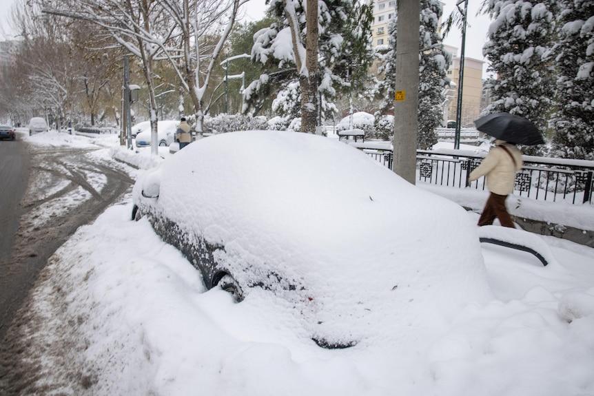
November 20, 2021 at 9:24 AM #182302Record snow falls in parts of north-east China
Large parts of northern China, including the capital Beijing, have been hit by freezing temperatures and record snowfall, blanketing streets and causing travel delays A cold wave earlier this week saw temperatures plunge by as much as 14 degrees Celsius Snowstorms blocked roads and halted travel Recent snowfall in the region has been the heaviest since records began 70 years ago China’s National Meteorological Agency raised an orange blizzard warning – the second-highest in China’s four-tiered alert system – with snowfall of up to 30 centimetres forecast in coming days. The country’s first snowfall of the year came a month earlier than usual, according to the Beijing Meteorological Bureau. Snowstorms have wreaked havoc in the region with slippery road conditions for motorists, and one weather-related fatality reported by the People’s Daily newspaper.
Honorary Member
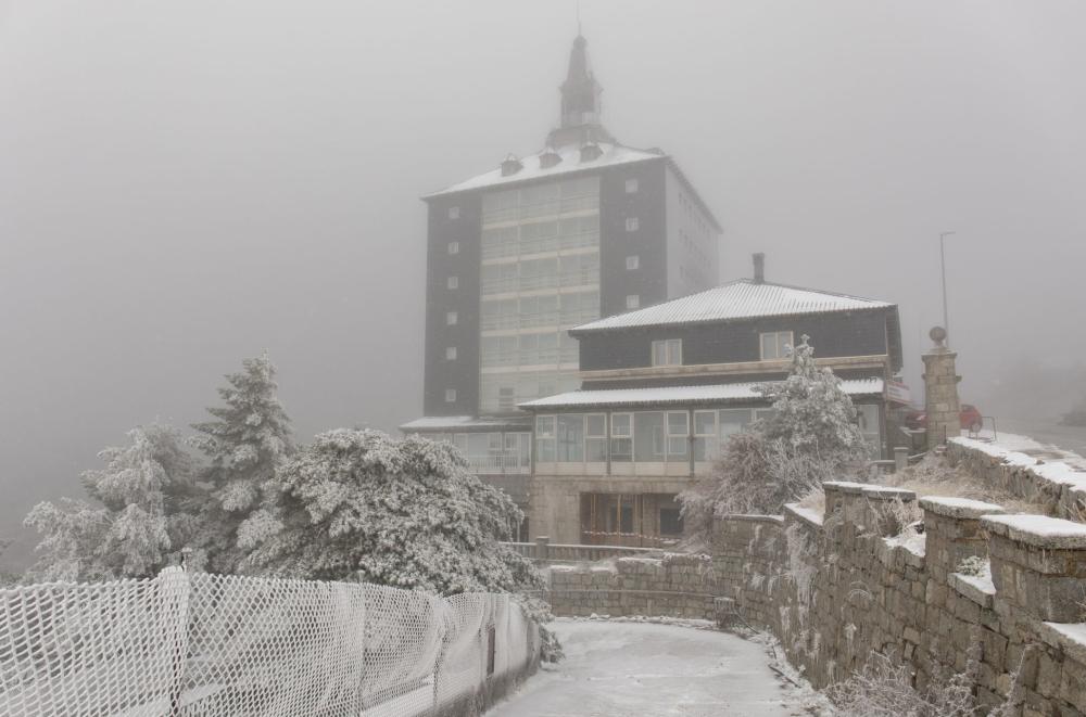
November 24, 2021 at 9:20 AM #182462Ten Spanish regions were on alert for snowfall on Tuesday as the country braced for the brunt of the first winter storm of the season. The storm – which arrived on Monday, 10 days before the meteorological start of winter – is caused by the “arrival of a mass of cold air from high altitudes that has triggered a sudden drop in temperatures,” said Rubén del Campo, the spokesperson of Spain’s national weather agency Aemet. According to Del Campo, this mass of cold air has also brought about a slow-moving storm system, known officially as an upper-level isolated depression (DANA) but more popularly known in Spain as a gota fría, or literally cold drop. On Tuesday, Aragón, Castilla-La Mancha, Castilla y León and La Rioja were placed on orange alert for snowfall, which is the second-highest in Aemet’s three-tiered warning system. Asturias, Cantabria, Catalonia, the north of Madrid, Navarre and the Valencia region are on yellow alert, which is the lowest. In the last 24 hours, snow has been falling at increasingly low altitudes, with snow recorded Monday night at 800 meters in the northmost part of the country. According to Spain’s traffic authority DTG, traffic restrictions were introduced on close to 750 kilometers of roads in 10 provinces, mostly in the north of Spain, due to the buildup of snow.
Honorary Member
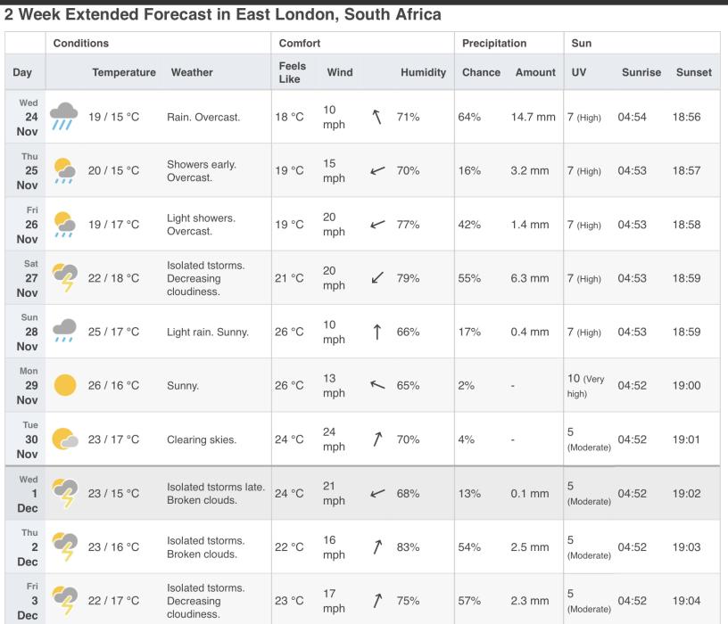
November 24, 2021 at 9:31 AM #182463@bobcat. Any chance of a forecast for South africa for next week? Are budge smugs required?
Collins Cp2 map. Ramair induction. Mountune mud flaps. Scorpion Sports Cat. Scorpion Tracker. Wind deflectors. NB washer jets and shark fin aerial. EBC Grooved discs, YellowStuff pads. Airtec Intercooler, Miltek cat back with titanium tips. Collins quickshift. DSC Controller
November 24, 2021 at 10:15 AM #182465@Turbo, SA that’s a big place 😹😹😹
https://www.weatheravenue.com/en/africa/za/western-cape/cape-town-weather-15-days.html
Honorary Member
November 24, 2021 at 10:16 AM #182466Also
Honorary Member
-
This reply was modified 2 years, 5 months ago by
-
AuthorPosts